

 'Important if true” was the phrase that the 19th-century writer and historian Alexander Kinglake wanted to see engraved above church doors. It rings loud in the ears as one reads the latest book by Graham Robb, a biographer and historian of distinction whose new work, if everything in it proves to be correct, will blow apart two millennia of thinking about Iron Age Britain and Europe and put several scientific discoveries back by centuries.
Rigorously field-tested by its sceptical author, who observes drily that “anyone who writes about Druids and mysteriously coordinated landscapes, or who claims to have located the intersections of the solar paths of Middle Earth in a particular field, street, railway station or cement quarry, must expect to be treated with superstition”, it presents extraordinary conclusions in a deeply persuasive and uncompromising manner. What surfaces from these elegant pages – if true – is nothing less than a wonder of the ancient world: the first solid evidence of Druidic science and its accomplishments and the earliest accurate map of a continent.
Robb begins his journey from a cottage in Oxfordshire, following up a handful of mysteries that had teasingly accrued as he assembled his Ondaatje Prize-winning travelogue The Discovery of France.
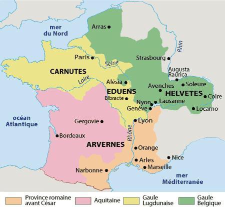
They had to do with the Heraklean Way, an ancient route that runs 1,000 miles in a straight line from the tip of the Iberian Peninsula to the Alps, and with several Celtic settlements called Mediolanum arranged at intervals along the route.
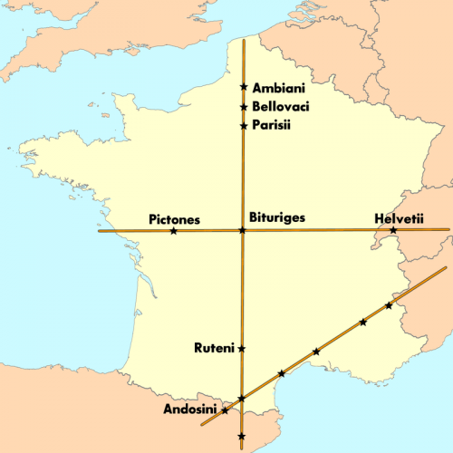
After examining satellite imaging (difficult for the private scholar even a decade ago) and making several more research trips, Robb bumped up against two extraordinary discoveries. First, the entire Via Heraklea runs as straight as an arrow along the angle of the rising and setting sun at the solstices. Second, plotting lines through the Celtic Mediolanum settlements results in lines that map on to sections of Roman road, which themselves point not to Roman towns but at Celtic oppida farther along.
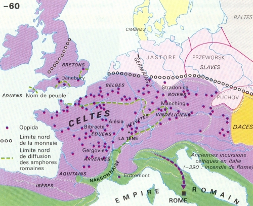
Viewed in this light, the ancient texts of the Italian conquerors begin to reveal sidelong secrets about the people they supplanted. Piece by piece, there emerges a map of the ancient world constructed along precise celestial lines: a huge network of meridians and solar axes that served as the blueprint for the Celtic colonisation of Europe, dictated the placement of its settlements and places of worship, and was then almost wholly wiped from history. We are, to put it mildly, unused to thinking like this about the Celts, whose language is defunct and whose reputation was comprehensively rewritten by those who succeeded them.
Greek travellers from the sixth century BC onwards described a nation of sanguinary brutes and madmen who threw their babies in rivers, walked with their swords into the sea and roughly sodomised their guests. “It does not take an anthropologist to suspect,” Robb observes drily, “that what the travellers saw or heard about were baptismal rites, the ceremonial dedication of weapons to gods of the lower world, and the friendly custom of sharing one’s bed with a stranger.”
Later on, clean-shaven, toga-sporting Roman visitors to what they called Gallia Bracata and Gallia Comata – Trousered Gaul and Hairy Gaul respectively – were horrified by the inhabitants’ practical legwear and love of elaborate moustaches, and marvelled to hear them discoursing not in gnarly Gaulish but in perfect Greek.
As the Roman military machine rolled over Europe, depicting the Celt as a woods-dwelling wild man became not just a matter of Italian snobbery but one of propagandist utility. According to Robb, when the Romans arrived this side of the Alps, they found a country whose technical achievements were different from, but competitive with, their own.
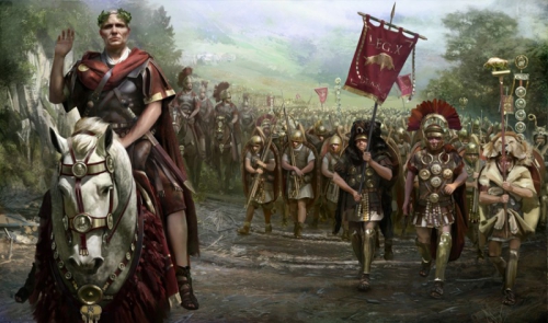
Mapped and governed by a network of scholar-priests according to a template laid down in heaven, covered by a road network that afforded swift passage to fleets of uniquely advanced chariots (“nearly all the Latin words for wheeled vehicles”, Robb notes, “come from Gaulish”) and possessing astronomical and scientific knowledge that would take another millennium to surface again, Gaul remained a deeply enigmatic place to its military-minded conquerors. When Julius Caesar swept through, on a tide of warfare and genocide that would lead his countryman Pliny to accuse him of humani generis iniuria, “crimes against humanity”, much of its knowledge retreated to the greenwood, never to emerge.
Most significantly, suggests Robb, Caesar failed to work out the Druids. To most of us even now, the word conjures up the image of a white-robed seer with a sickle, an implausible hybrid of Getafix and Glastonbury hippie. (Robb suggests, following the design on a Gaulish cauldron, that they tended more towards a figure-hugging costume patterned like oak bark: much better for melting like smoke into the trees, a trait of Druid-led armies that Caesar vigorously deplored.) The Druidic curriculum took two decades to train up its initiates, but these men of science put nothing in writing. Like their wood-built houses, their secrets rotted with time. How could we hope to reconstruct them?
Remarkably, Robb has an answer to this, and it forms the centre of a book almost indecently stuffed with discoveries. One of the most consistently baffling things about Celtic temple sites to modern surveyors is their shape: warped rectangles that seem none the less to demonstrate a kind of systematic irregularity. Using painstakingly reconstructed elements of the Druidic education, which placed religious emphasis on mapping the patterns of the heavens on to the lower “Middle Earth” of our world, Robb comes up with an astonishing discovery: these irregular rectangles exactly match a method for constructing a geometrical ellipse, the image of the sun’s course in the heavens. Such a method was previously thought to be unknown in the West until the 1500s.
Other suggestions follow thick and fast, backed by a mixture of close reading, mathematical construction and scholarly detective work. Building on meridians and equinoctial lines, the Druids used their maps of the heavens to create a map that criss-crossed a continent, providing a plan of sufficient latitudinal and longitudinal accuracy to guide the Celtic diaspora as it pushed eastward across Europe.
The swirls and patterns in Celtic art turn out, Robb surmises, to be arranged along rigorous mathematical principles, and may even encode the navigational and cartographic secrets that the Druids so laboriously developed.
Robb manages his revelations with a showman’s skill, modestly conscious that his book is unfurling a map of Iron Age Europe and Britain that has been inaccessible for millennia. Every page produces new solutions to old mysteries, some of them so audacious that the reader may laugh aloud. Proposing a new location for Uxellodunum, the site of the Gauls’ final losing battle in France, is one thing; suggesting where to look for King Arthur’s court, or which lake to drag for Excalibur, is quite another. But both are here.
Amid such riches, readers of The Discovery of France – a glorious book that mixed notes from a modern cycling tour with a historical gazetteer of pre-unification France – may still be itching for the moment when the author gets back on his bike. Beautifully written though it is, The Ancient Paths can tend to dryness at times, but some of its best moments come when the author gets out into the field.
One example will suffice. Certain references in Caesar’s writing indicate that the Gauls operated a vocal telegraph, composed of strategically placed teams yodelling news overland to one another, which passed messages at a speed nearly equivalent to the first Chappe telegraph in the 18th century. To judge how this might have worked, Robb takes himself off to the oppidum above Aumance, near Clermont-Ferrand, where he reports on the car alarms and the whirr of traffic still audible across countryside four kilometres away.
He goes further. Aumance was one of around 75 places once known by the name Equoranda, a word with an unknown root that resembles the Greek and Gaulish for “sound-line” or “call-line”. All the Equoranda settlements Robb visits turn out to be on low ridges or shallow valleys, and would, he writes, “have made excellent listening posts”. Examined in this light, one word in Caesar’s account becomes fruitful: he observes that the Gauls “transmit the news by shouting across fields and regios”, a word that can be translated as “boundaries”. An ancient Persian technique for acoustic surveying, still current in the 19th-century south of France, involves three men calling to one another and plotting their position along the direction of the sound. Put the pieces together and you end up – or Robb does – with “the scattered remains of a magnificent network” that could have acted not just as a telegraph system but as a means to map the Druids’ boundaries on to the earth.
It’s a magnificent piece of historical conjecture, backed by a quizzical scholarly intellect and given a personal twist by experiment. So, for that matter, is
the whole thing. Robb describes in his introduction the secretive meetings with publishers in London and New York that kept a lid on the book’s research until publication, and watching its conclusions percolate through popular and academic history promises to be thrilling.
Reading it is already an electrifying and uncanny experience: there is something gloriously unmodern about seeing a whole new perspective on history so comprehensively birthed in a single book. If true, very important indeed.

The Ancient Paths: Discovering the Lost Map of Celtic Europe, by Graham Robb (Picador, RRP £20, Ebook £6.02), is available to order from Telegraph Books at £26 + £1.35p&p. Call 0844 871 1515 or visit books.telegraph.co.uk

 del.icio.us
 Digg
Digg Facebook
Les commentaires sont fermés.