


vendredi, 08 mai 2015
Arkaim — The Russian Stonehenge
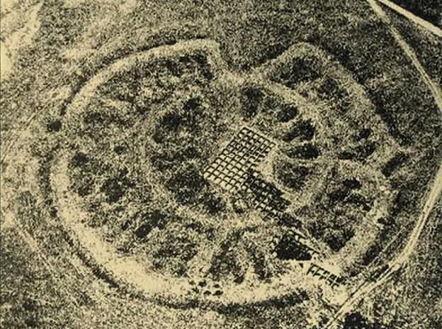
IN THE MODERN Russia, perhaps, you can’t find another archaeological site, which would exhibit such interest to itself by refined intellectuals, various politicians and the media. The Arkaim has spawned many myths – but still a little over ten years ago, nobody knows about it, even professionals. (ILLUSTRATION: Arkaim with a bird’s-eye view)
Unplanned opening of the Arkaim
It all started very modestly. In the summer of 1987, archaeologists of the Chelyabinsk State University conducted a routine survey of archaeological sites in the Big Karagansk Valley, in the south-west of the Chelyabinsk region.
It was expected to flood the valley to stage a vast reservoir for neighboring farms. The builders hurried, and archaeologists were in a hurry to descendants make a map of the ancient monuments and never to come back here. But researchers have attracted the attention of trees, which, as it turned out, was surrounded by an unusual type of settlement – such has never been in the steppe zone.
It was about the diameter of a circular fortified settlement of about 150 meters, which included dozens of residential half-underground houses with the centers, cellars, wells and Steel Mining. The entire complex, called Arkaima, was originated in the 17 – 16th centuries BC. – It was hard to believe it!
The Map of Arkaim
He did not have to remain in splendid isolation – in a short time, archaeologists have discovered at least two dozen of these rounds or rectangular mounds, located in the Chelyabinsk and Orenburg regions, as well as in Bashkortostan and Northern Kazakhstan. All of them, on the assumptions of archaeologists, originated in 18th – 16th century BC!
What is surprising in all this? In recent decades, the world of science erupted again interest in the Indo-European issues: Where is the homeland of the Indo-Europeans, what was their ancient culture and how it has evolved, which hosted the migration routes of their individual groups.
Many of the Soviet archaeologists were convinced that the main settlement area of early Indo-Europeans was the steppe and forest-steppe of Eurasia, where the Late Stone Age and the Bronze Age cultures were formed predominantly pastoral population, subsequently gave rise to the great cultures of the Scythian world.
According to many experts, the Arkaim and related sites could be created by ancient Indo-Iranians long before their separation, relocations over the Eurasian steppe and traffic corridor to the south of Iran and India.
Some of the scientists have drawn parallels between the circular fortified settlements such Arkaima and the city of the legendary king Yima reproduces the model of the universe and described in “Avesta” – the sacred book of the ancient Iranians.
The Arkaim’s Architecture
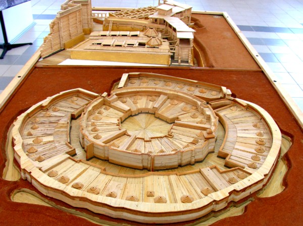
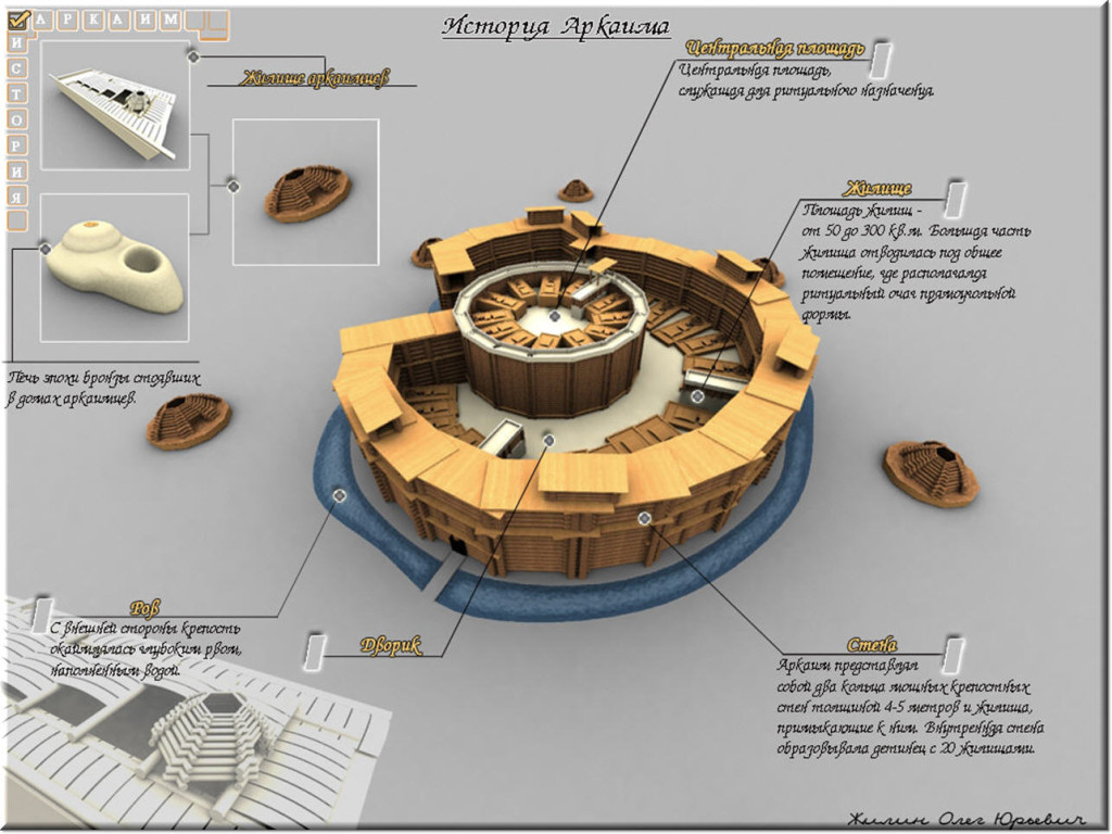
Arkaim is not only a city, but also a temple and an astronomical observatory! It has a circular shape, an outer diameter of approximately 160 meters. Surrounded by his 2 meter bypass ditch, filled with water. The outer wall is very massive. At a height of 5.5 m, it was a five-meter wide. There were identified four inputs on the wall. The largest – south-west, the other three – a little less, located on opposite sides.
The Plan of Arkaim
Entering the city, we can find ourselves on a single circular street, of a width of about 5 meters separating adjacent to the outer wall of the dwelling from the inner ring of walls.
Street had a log deck, under which, along its entire length was dug 2-meter ditch communicating with the external bypass ditch.
Thus, the city had a storm sewer – excess water seeping through corduroy, fell into a ditch and then into the outer bypass ditch.
All the dwellings adjacent to the outer wall like a slice of lemon, had access to the main street. It was discovered 35 houses out of the circle.
Next, we can see a mysterious ring on the inner wall. It was even more massive than the outer. With a width of 3 meters, it reached a 7-meter height.
The Reproduction of Arkaim
This wall, according to the site does not have the passage, except for a short break in the Southeast. Thus, the 25 domestic dwellings of identical dwellings of the outer circle, are effectively isolated from all high and thick walls.
To come to the little door of the inner ring, you had to go through the entire length of the circular street. This is pursued not only a defensive purpose, but also had a hidden meaning.
Inbound to the city had to take the path that passes the Sun. Apparently, in a well-protected inner circle were those who possessed something that should not even show her living in the outer circle, not to mention the external observers.
And finally, the crowning Arch central area of almost a square shape, about 25 by 27 meters.
Judging from the remains of fires in a given order, it was the area of the commission of certain sacraments.
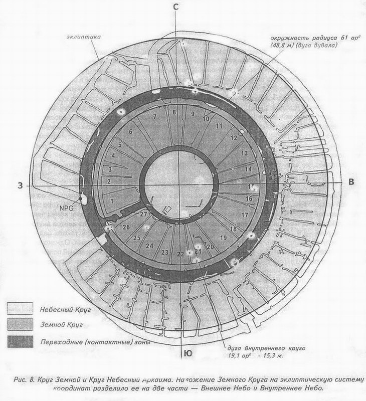
Thus, we see a schematic Mandala – a square inscribed in a circle. In the ancient cosmogonies texts circle represents the universe, the square – Earth, our material world.
The ancient wise man, knowing only appliance space, seen as perfectly natural and it works. Therefore the construction of the city as it – is a re-created the universe in miniature.
Also impressed with the engineering genius of the ancient builders. The Arkaim was built on a pre-engineered plan as a single complicated complex, and oriented to astronomical objects with great accuracy!
The figure formed by four entrances in the outer wall of Arkaim is a swastika. And it is the “right” swastika, it aimed at the sun.
Arkaim as an ancient observatory and its similarity with The Stonehenge
Very curious findings of the famous Russian astronomical-archaeologist Konstantin Bystrushkin., which conducted research Arkaim as an astronomical observatory in 1990-1991.
As Konstantin described, Arkaim – the construction is not just difficult, but even sophisticated complex. In the study the plan, Konstantin immediately found his resemblance to the famous monument of Stonehenge in England.
For example, the diameter of the inner circle of Arkaim indicates all of 85 meters, in fact it is a ring with two radii – 40 and 43.2 meters. (Try to draw!)
Meanwhile, the radius of the “Aubrey holes” ring, at Stonehenge – 43.2 meters! The Stonehenge, and the Arkaim are located on the same latitude, both in the center of a bowl-shaped valley. And between them are almost 4,000 kilometers …
Summing up all the facts obtained, we can say: Arkaim is a sub-Horizont Observatory. Why sub-Horizont? Because the measurements and observations used the moment of sunrise and sunset luminaries (Sun and Moon) to the horizon.
And pinpoint the time of “separation” (or touch) the lower edge of the disc, which allows the most accurate pinpoint location of the event. If you watch the sunrise, we note that the point of sunrise each day will move from its previous location.
Reaching the maximum north on June 22, this point then moves south, reaching to the other at the level of December 22. This is the cosmic order.
The number is clearly visible points of observation of the Sun – four. Two – the point of sunrise on June 22 and December 22, and two of the same points of call – on the other side of the horizon. Add two points – the moments of the equinox on March 22 and September 22. This gave a fairly accurate determination of the length of the year.
The Sources: The Library of the Alternative History, The Skeptik
Translated by: Alex Cardo
* * *
Source: Traveling Myself
00:05 Publié dans archéologie | Lien permanent | Commentaires (0) | Tags : arkaîm, russie, archéologie, préhistoire, proto-histoire |  |
|  del.icio.us |
  |
|  Digg |
  Facebook
Les commentaires sont fermés.