

This is arguably the ultimate road trip on earth. Marco Polo did it. All the legendary Silk Road explorers did it. Traveling the Pamir Highway back to back, as a harsh winter approaches, able to appreciate it in full, in silence and solitude, offers not only a historical plunge into the intricacies of the ancient Silk Road but a glimpse of what the future may bring in the form of the New Silk Roads.
This is a trip steeped in magic ancient history. Tajiks trace their roots back to tribes of Sogdians, Bactrians and Parthians. Indo-Iranians lived in Bactria (“a country of a thousand towns”) and Sogdiana from the 6-7th centuries BC to the 8th century AD Tajiks make up 80% of the republic’s population, very proud of their Persian cultural heritage, and kin to Tajik-speaking peoples in northern Afghanistan and the region around Tashkurgan in Xinjiang.
Proto-Tajiks and beyond were always at the fringe of countless empires – from the Achaemenids, Kushan and Sogdians to the Greco-Bactrians, the Bukhara emirate and even the USSR. Today many Tajiks live in neighboring Uzbekistan – which is now experiencing an economic boom. Due to Stalin’s demented border designs, fabled Bukhara and Samarkand – quintessential Tajik cities – have become “Uzbek.”
Bactria’s territory included what are today northern Afghanistan, southern Tajikistan and southern Uzbekistan. The capital was fabled Balkh, as named by the Greeks, carrying the informal title of “mother of all cities.”
Sogdiana was named by the Greeks and Romans as Transoxiana: between the rivers, the Amu-Darya and the Syr-Darya. Sogdians practiced Zoroastrianism and lived by arable agriculture based on artificial irrigation.
We all remember that Alexander the Great invaded Central Asia in 329 B.C. After he conquered Kabul, he marched north and crossed the Amu-Darya. Two years later he defeated the Sogdians. Among the captured prisoners was a Bactrian nobleman, Oxyartes, and his family.
Alexander married Oxyartes’s daughter, the ravishing Roxanne, the most beautiful woman in Central Asia. Then he founded the city of Alexandria Eskhata (“The Farthest”) which is today’s Kojand, in northern Tajikistan. In Sogdiana and Bactria, he built as many as 12 Alexandrias, including Aryan Alexandria (today’s Herat, in Afghanistan) and Marghian Alexandria (today’s Mary, formerly Merv, in Turkmenistan).
By the middle of the 6th century, all these lands had been divided among the Turkic Kaghans, the Sassanian Empire and a coalition of Indian kings. What always remained unchanged was the emphasis on agriculture, town planning, crafts, trade, blacksmithing, pottery, manufacture of copper and mining.
The caravan route across the Pamirs – from Badakshan to Tashkurgan – is the stuff of legend in the West. Marco Polo described it as “the highest place in the world.” Indeed: the Pamirs were known by the Persians as Bam-i-Dunya (translated, appropriately, as “roof of the world”).
The highest peaks in the world may be in the Himalayas. But the Pamirs are something unique: the top orographic crux in Asia from which all the highest mountain ranges in the world radiate: the Hindu Kush to the northwest, the Tian Shan to the northeast, and the Karakoram and the Himalayas to the southeast.
Ultimate imperial crossroads
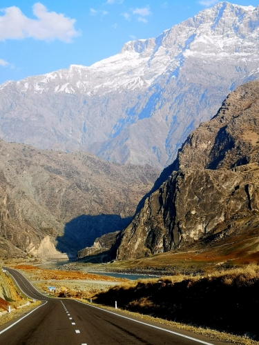
The Pamirs are the southern boundary of Central Asia. And let’s cut to the chase, the most fascinating region in the whole of Eurasia: as wild as it gets, crammed with breathtaking peaks, snow-capped spires, rivers ragged with crevasses, huge glaciers – a larger-than-life spectacle of white and blue with overtones of stony gray.
This is also the quintessential crossroad of empires – including the fabled Russo-British 19th century Great Game. No wonder: picture a high crossroads between Xinjiang, the Wakhan Corridor in Afghanistan and Chitral in Pakistan. Pamir may mean a “high rolling valley.” But the bare Eastern Pamirs might as well be on the moon – traversed less by humans than curly-horned Marco Polo sheep, ibex and yaks.
Countless trade caravans, military units, missionaries and religious pilgrims also made the Pamir Silk Road known as “road of Ideologies.” British explorers like Francis Younghusband and George Curzon hit the upper Oxus and mapped high passes into British India. Russian explorers such as Kostenko and Fedchenko tracked the Alai and the great peaks of the northern Pamir. The first Russian expedition arrived in the Pamirs in 1866, led by Fedchenko, who discovered and lent his name to an immense glacier, one of the largest in the world. Trekking toward it is impossible as winter approaches.
And then there were the legendary Silk Road explorers Sven Hedin (in 1894-5) and Aurel Stein (1915), who explored its historical heritage.
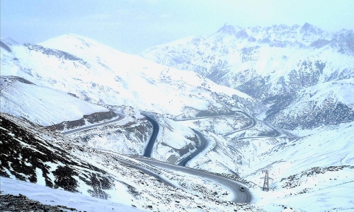
The Pamir Highway version of the Silk Road was actually built by the Soviet Union between 1934 and 1940, predictably following ancient caravan tracks. The name of the region remains Soviet: the Gorno-Badakhshan Autonomous Oblast (GBAO). To travel the highway, one needs a GBAO permit.
For no less than 2,000 years – from 500 B.C. to the early 16th century – camel caravans carried not only silk from East to West, but goods made of bronze, porcelain, wool and cobalt, also from West to East. There are no fewer than four different branches of the Silk Road in Tajikistan. The ancient Silk Roads were an apotheosis of connectivity: ideas, technology, art, religion, mutual cultural enrichment. The Chinese, with a keen historical eye, not by accident identified “common legacy of mankind” as the conceptual/philosophical base for the Chinese-led New Silk Roads, or Belt and Road Initiative.
Have China upgrade, will travel
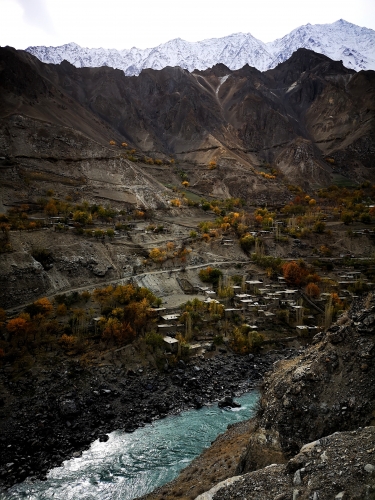
In villages in Gorno-Badakhshan, stretched out along stunning river valleys, life for centuries has been about irrigation farming and seasonal-pasture cattle farming. As we progress toward the barren Eastern Pamirs, the story mutates into an epic: how mountain people eventually adapted to living at altitudes as high as 4,500 meters.
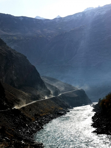
In the Western Pamirs, the current road upgrade was by – who else? – China. The quality is equivalent to the northern Karakoram Highway. Chinese building companies are slowly working their way towards the Eastern Pamirs – but repaving the whole highway may take years.
The Pyanj river draws a sort of huge arc around the border of Badakhshan in Afghanistan. We see absolutely amazing villages perched on the hills across the river, including some nice houses and owners with an SUV instead of a donkey or a bike. Now there are quite a few bridges over the Pyanj, financed by the Aga Khan foundation, instead of previous planks jammed with stones suspended above vertiginous cliffs.
From Qalaykhumb to Khorog and then all the way to Ishkoshim, the Pyanj river establishes the Afghan border for hundreds of kilometers – traversing poplar trees and impeccably-tended fields. Then we enter the legendary Wakhan valley: a major – barren – branch of the Ancient Silk Road, with the spectacular snow-capped peaks of the Hindu Kush in the background. Farther south, a trek of only a few dozen kilometers of trekking, it’s Chitral and Gilgit-Baltistan in Pakistan.
The Wakhan could not be more strategic – contested, over time, by Pamiris, Afghans, Kyrgyz and Chinese, peppered with qalas (fortresses) that protected and taxed the Silk Road trade caravans.
The star of the qalas is the 3rd century B.C. Yamchun fortress – a textbook medieval castle, originally 900 meters long and 400 meters wide, set in a virtually inaccessible rocky slope, protected by two river canyons, with 40 towers and a citadel. Legendary Silk Road explorer Aurel Stein, who was here in 1906, on the way to China, was gobsmacked.The fortress is locally known as the “Castle of the Fire Worshippers”.
Pre-Islamic Badakhshan was Zoroastrian, worshipping fire, the sun and spirits of ancestors and at the same time practicing a distinct Badakhshani version of Buddhism. In fact, in Vrang, we find the remains of 7th-8th century Buddhist man-made caves that could have also been a Zoroastrian site in the past. The early Tang dynasty wandering monk Xuanzang was here, in the 7th century. He described the monasteries and, tellingly, took notice of a Buddhist inscription: “Narayana, win.”
Ishkoshim, which Marco Polo crossed in 1271 on the way to the upper Wakhan, is the only border crossing in the Pamirs into Afghanistan open to foreigners. To talk of “roads” on the Afghan side is audacious. But old Silk Road tracks remain, negotiable only with a study Russian jeep, delving into Faizabad and farther into Mazar-i-Sharif.
Here are the parts the 18-year-long, trillion-dollar, Hindu Kush-of-lies-told American war on Afghanistan never reaches. The only “America” available is Hollywood blockbusters on DVDs at 30 cents apiece.
I was very fortunate to spot the real deal: a camel caravan, straight from the ancient Silk Road, following a track on the Afghan side of the Wakhan. They were Kyrgyz nomads. There are roughly 3,000 Kyrgyz nomads in the Wakhan, who would like to resettle back in their homeland. But they are lost in a bureaucratic maze – even assuming they secure Afghan passports.
These are the ancient Silk Roads the Taliban will never be able to reach.
Traveling the Pamir Highway, we’re not only facing a geological marvel and a magic trip into ancient history and customs. It’s also a privileged window on a trade revival that will be at the heart of the expansion of the New Silk Roads.
Khorog is the only town in the Pamirs – its cultural, economic and educational center, the site of the multi-campus University of Central Asia, financed by the Agha Khan foundation. Ismailis place tremendous importance on education.
Badakhshan was always world-famous for lapis lazuli and rubies. The Kuh-i-Lal ruby mine, south of Khorog, was legendary. Marco Polo wrote that in “Syghinan” (he was referring to the historical district of Shughnan) “the stones are dug on the king’s account, and no one else dares dig in that mountain on pain of forfeiture of life”.
Shughnan worshipped the sun, building circular structures with the corresponding solar symbolism. This is what we see in Saka graves in the Eastern Pamir. As we keep moving east, the settled Pamiri culture, with its profusion of orchards of apricots, apples and mulberries, gives way to semi-nomadic Kyrgyz life and irrigated villages are replaced by seasonal yurt camps (not at this time of the year though, because of the bitter cold.)
At Langar, the last village of the Wakhan, rock paintings depict mountain goats, caravans, horse riders with banners, and the Ismaili symbol of a palm with five fingers. Archeologist A. Zelenski, in fascination, called the historical monuments of the Wakhan “the Great Pamir Route.” Aurel Stein stressed this was the main connection between Europe and Asia, thus between the whole classical world and East Asia, with Central Asia in between. We are at the heart of the Heartland.
Last stop before Xinjiang
Following the Wakhan all the way would lead us to Tashkurgan, in Xinjiang. The Pakistani border, close to the Karakoram Highway, is only 15 km to 65 km away, across forbidding Afghan territory.
It’s the Koyzetek pass (4,271 meters) that finally leads to the Eastern Pamir plateau, which the Chinese called Tsunlin and Ptolomy called Iamus, shaped like a giant shallow dish with mountain ranges at the edges and lakes at record altitudes. Marco Polo wrote, “The land is called Pamier, and you ride across it for twelve days together, finding nothing but a desert without habitations or any green thing, so that travelers are obliged to carry with them whatever they need. The region is so lofty and cold that you don’t even see any birds flying. And I must notice also that because of this great cold, fire does not burn so brightly and give out so much heat as usual, not does it cook effectually.”
Murghab, peopled by Kyrgyz – whose summers are spent in very remote herding camps – revolves around a mini-bazaar in containers. If we follow the Aksu river – once considered the source of both the water and the name of the Oxus – we reach the ultimate, remote corner of Central Asia: Shaymak – only 80 km from the tri-border of Afghanistan, Pakistan and China.
The Little Pamirs are to the south. As I reported for Asia Times way back in 2001, it was in this area, crammed with the most important Silk Roads passes of both China and Pakistan, that Osama bin Laden might have been hiding, before he moved to Tora Bora.
From Murghab, I had to inspect the Kulma pass (4,362 meters high), a New Silk Road border. The road – made by China – is impeccable. I found lonely Chinese container truck drivers and businessmen from Kashgar driving made-in-China minivans across the Pamirs to be sold in Dushanbe.
On the High Pamirs we find around 800 ancient lakes created by earthquakes, tectonic activity and glaciers. Yashilkul lake (“Blue Water”), at 3,734 meters frozen this time of the year, sits in a plateau scouted by Stone Age hunters. Tajik archeologist V. Ranov found rock paintings of horses and carts, attributes of Mitra, the Persian god of the Sun. During the 10th to 3rd centuries B.C, the plateau was inhabited by nomadic tribes of the Persian-speaking Sakas.
From Shughnan to Ishkoshim, here we are in what the ancients called “The country of the Sakas.”
From Scythians to containers
The vast Scythian steppes that range from the Danube all the way to China were inhabited by a vast confederation of tribes. Then, in the 2nd to 1st centuries B.C., the tribes started moving to the east of the Greco-Bactrian state. Some of them settled in the Pamirs and became the ethno-genetic component of the Pamiri ethnicity. Alex, my driver, is a true Pamiri from Khorog. He’s also the real Pamir Highway Star with his badass black Land Cruiser. (“It’s a killing machine/ it’s got everything,” as Deep Purple immortalized it.)
The highlight of the Eastern Pamirs is the spectacular blue inland, saltwater Karakul Lake, formed 10 million years ago by a meteor. Under the sun, it’s a radiant turquoise; this time of the year, I saw it deep, deep blue, not really the “Black Lake” that its name implies. Karakul because of its slight salinity was not frozen. This is chong (big) Karakul, the older brother of the kichi (small) Karakul across the border in Xinjiang, which I had the pleasure of visiting in my Karakoram Highway travels.
The High Pamirs are right behind Karakul, concealing the 77-km-long Fedchenko glacier. East of the lake, if you could survive a trek in Arctic conditions, is Xinjiang. The early Tang dynasty wandering monk Xuanzang was here in 642 (he thought the lake was people by dragons). Marco Polo was here in 1274.
Our base to explore Yashilkul and later Karakul was Bulungkul – this time of the year a sort of Arctic station, with only 40 houses served by solar panels in the middle of nowhere, and temperatures hovering around minus 22 Celsius. It’s the toughest of lives. They told me that in winter the temperature drops to -63C.
Farther down the road, I took a diversion east to observe the Kulma pass, at 4,363 meters the official Tajik border with China, reached by a – what else? – made-by-China road, opened in 2004 following the ancient Silk Road.
The Tajik-Kyrgyz border at the Kyzyl-Art pass looked like a scene from Tarkovsky’s Stalker, utterly Soviet-style desolate except for a shared taxi loaded with Kyrgyz going to Khorog. From there, it’s a spectacular drive all the way to the crossroads of Sary Tash, and through the head-spinning, 3,615 meter-high Taldyk pass, towards Osh, the gateway to the Ferghana valley.
All across this mesmerizing Central Asia/Heartland journey, especially in the bazaars, we see in detail the crossroads of pastoral nomadism and irrigation culture, fertilized century after century by cross-cultural Silk Road trade involving herders, farmers, merchants, all of them part of commodity trading and provisioning for the caravans.
We delve into the vortex of immensely rich social, religious, scientific, aesthetic and ideological influences – especially from Persia, India, China and Iran. The shift from overland to sea trade in the 16th century – the start of European world domination – in fact never erased the traditional routes to India via Afghanistan, China via Xinjiang and Europe via Iran. Trade remains the top factor in Central Asian life.
Today the Pamir Highway is a privileged microcosm of what is slowly but surely evolving as the intersection between the New Silk Roads and Greater Eurasia – with its main hubs configured by Russia, China, Iran, Pakistan and – it may be hoped – India.
The ultimate crossroads of civilizations, the Heartland, is back – once again at the heart of history.

 del.icio.us
 Digg
Digg Facebook